Monthly Archives

January 2024

Just Add Water: Pre-settlement Water, Land, People Relationships in the Poudre River Valley

By Stories

The Poudre River’s recorded history, prior to gold seekers and settlers arriving in the late 1850s and early 1860s, is scarce.  There were fur trappers’ and explorers’ writings of the area, but these were very limited regarding the Poudre River.  It was during this period that the river obtained its name, but the exact reasons and timing are uncertain.  It is generally agreed that fur traders/trappers needed to stash some of their supplies (including gun powder – in French it becomes ‘Cache la Poudre’), for a short time, during the 1820s or 1830s, for some reason, and the river was named for this action. 

As gold seekers and settlers encountered the Poudre River Valley in the mid-1800s, I often wonder what they saw.  We know that the river today is not like the natural stream before it was adapted to support permanent settlement of large numbers of people.   

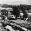
Before permanent settlement in the Poudre River valley, the river meandered in a shallow, braided fashion through the bottomlands.  Each spring, runoff flooded (i.e. ‘irrigated’) the valley bottomlands in such a manner that there was an excellent stand of native grasses growing across the valley floor from the mouth of the canyon to the mouth of the river, east of Greeley.  One place, open to the public, to visualize this low, flat, bottomlands is the Arapaho Bends Natural Area.  As you stand near the remains of the Strauss Cabin, you can gaze across the valley floor (removing Rigden Reservoir from visualization) toward the west and see the bluff with Ziegler Road on top.  Look east to the bluff where I-25 is now located with the town of Timnath on the east side of the interstate.  Looking upstream the valley widens as the Box Elder Creek enters the Poudre River.  Imagine the entire bottomland area covered with native grasses and trees growing along the river meandering through the valley. 

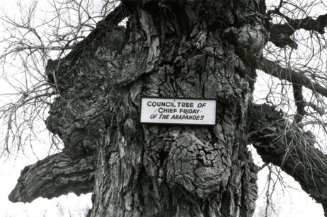
The lushness of grasses drew buffalo into the valley.  It becomes rather obvious why the Native Americans used the area to camp – food, water, fuel – all in abundance.  Just north of the Strauss Cabin, across the railroad tracks, is where the Council Tree was located.  Large numbers of Native Americans could camp in the vicinity to ‘Council’, as the early setters called Native American gatherings, – i.e. transact business, socialize, and conduct ceremonies – while living comfortably on the resources provided by the river. 

This lushness did not escape the attention of earlier settlers to the area.  George Strauss (1858) and Benjamin Eaton (1859), traveling through the area on other missions, noted the lushness and both returned to settle in the valley when their missions were completed.  The Coy family decided to over-winter in the valley on their way to California in 1862, but did not continue their trip when spring arrived.  The Valley is a beautiful place where many people, over the years, have chosen to settle. 

The Northern Arapaho, under the leadership of ‘Chief’ Friday, were the last band of Native Americans to live/visit the Poudre River Valley, being forced out in the late 1860s.  Before leaving, they requested a reservation on the north bank of the Poudre River, on which to live, but were denied.  Friday’s band eventually was assigned to live on the Wind River Indian Reservation in central Wyoming. 


References:

Silkensen, G. 1993. South Platte River Observations: Historical Clues to the Evolution of a River’s Ecology. Published in the Proceedings of the 1992 South Platte Conference, Information Series Number 72, Colorado Water Institute, Colorado State University, pages 41-56. http://www.cwi.colostate.edu/publications/IS/72.pdf

Simmons, Marc. 2004. Friday: the Arapaho Boy – a Story from History. Children of the West Series, University of New Mexico Press, Albuquerque. 

Burris, Lucy. 2006. People of the Poudre: An Ethnohistory of the Cache la Poudre River National Heritage Area, AD 1500-1880. (Published through a cooperative agreement between the National Park Service, Friends of the Poudre, and the Cache la Poudre River National Heritage Area)

Just Add Water: Why is there a National Heritage Area associated with the Cache la Poudre River?

By Stories

The main answer to this question is WATER!  The Poudre River’s water history is not unique in the western U.S. – many western rivers have similar stories about human attempts to survive in arid and semi-arid western river valleys.

What makes the Cache la Poudre River worthy of designation as a National Heritage Area is the manner in which its water history is interwoven into the broader fabric of western water law and technology.  The Poudre River’s history, in many ways, is an illustrative microcosm of western settlement that captures the essence of the struggles people faced in living in the dryness that defines the West and, in particular, how they adapted to survive, and thrive, in the dry landscape.  And further, the Poudre’s history shows how people continue, to this day, to adapt to new challenges, such as improving the ecological health of the river and providing for recreation on, and in, the river.       

As historian David McCullough notes:

History is the story of people. 

Water history in the Poudre River valley is no exception.  The series of stories that follow explains the role of the people of the Poudre in establishing western water law, water development strategies, new water management technology, and initial recognition of the need to create a sustainable relationship with the limited water environment that exists in much of the West.  Again, this need continues today as the population of the Poudre Valley continues to grow rapidly. 

The people did not set out to establish new water law, create new technology to manage water, or determine how to divide the limited waters of western rivers.  They set out to survive in a dry and harsh climate. As the people of the Poudre adapted to the dry climate, their efforts were innovative enough to be of assistance and use to other western States and many foreign countries. 

Organizing and presenting a large sweep of western water history, if even in only one valley, can be daunting if the presentation focuses on each discipline’s (i.e. law, engineering, agriculture, etc.) evolutionary path.  The approach used here will chronologically follow the people of the Poudre, explain the water challenges they faced in their day, and describe the manner in which they solved each challenge.  The solutions they created for each challenge, when combined over time, will help to explain how we arrived, collectively, at the system of western water management in use today and why there is a National Heritage Area associated with the Poudre River. 

Water history in the West is, in very general terms, about subsistence in the 1800s (the frontier was deemed ‘closed’ in 1890), development in the 1900s (the Bureau of Reclamation was created in 1902 and is now managing 180 projects), and sustainability as the 21st Century dawns (as ecosystem health, instream flows and recreational uses are debated, acknowledged, and incorporated into water law).  This overarching framework provides a background against which the people of the Poudre lived their lives and confronted water challenges facing each generation. 

Read the first story.  


References:

‘The Story of People’

National Park Service. 1990. Resource Assessment: Proposed Cache la Poudre River National Heritage Corridor. Prepared by the NPS Rocky Mountain Regional Office at the request of the City of Fort Collins, December  [Appendix B of this report is entitled: Historical Context – The History of Water Law and Water Development in the Cache la Poudre River Basin and the Rocky Mountain West]  Report can be accessed at:  https://archive.org/details/resourceassessme00nati

Information Source: These stories were prepared by Robert C. Ward, a professor and administrator at Colorado State University for 35 years, to assist in training volunteers on the history behind designation of the Poudre River as a National Heritage Area. [In particular, the information permits water history-related sites along the Poudre River to be explained through the lives of people who adapted their use of water to match the semi-arid nature of the landscape.]