
On the first of June 1844, I stuck my stake on a claim in the valley, intending the location selected for my home should the country ever be settled. At that time the streams were all very high and the valley black with buffalo…I thought the Poudre valley was the loveliest spot on earth and think so yet.

Antoine JanisAntoine Janis in letter to Ansel Watrous, 1911

As 1840 began along the Cache la Poudre, the river, foothills, animals, and people that called this land home—the Arapahoe, Cheyenne, and others—were yet unaware of the major changes the next thirty years would bring. Trappers were still relative newcomers to the region and the Fremont expeditions that put the Cache la Poudre solidly on the map would not arrive for a few years. (You can read more about the era of Fur Trappers and the Fremont Expeditions on “Exploring the River.”) But waves of change were sweeping towards the Poudre.

In 1843, the same year Fremont passed through the Poudre, the first wagon trains pulled away from the Missouri River headed towards Oregon Territory, on a route that would become the Oregon Trail. The earliest pioneers had their eyes set on Oregon & California and skirted around what would become Colorado with its impassable Rocky Mountains and prairies that had been labeled “The Great American Desert.” While the 1840s were quieter for the Cache la Poudre, one man had his eye on the valley.

Antoine Janis

Joseph “Antoine” Janis was born in 1824 in Missouri to a French father and Creole mother. His Father, Antoine St. Charles Janis, was a trader who worked transporting supplies for famed trapper William H. Ashley, founder of the Rocky Mountain Fur Company. In 1836, at twelve years old, Antoine joined his father on an expedition to present-day Colorado (Antoine later claimed they named the Cache la Poudre River on this trip, but the story is disputed, you can read more about the river name here). Antoine would go on to make his own life as a trapper, scout, and interpreter working out of (in present-day Wyoming). In 1844 he married First Elk Woman of the Ogalala Sioux tribe. Also in 1844, while on his way back from Mexico, Antoine Janis again passed through the Cache la Poudre River. Antoine was charmed by the area’s beauty (he called it the “loveliest spot-on earth”), but the area was still considered Native territory and not being settled, so Antoine staked a squatters claim near the river just west of present-day Laporte before returning to Fort Laramie.

Antoine Janis, the first Euro-American settler of Northern Colorado, worked as an interpreter out of Fort Laramie before settling along the Poudre. Arapaho leader Friday whose people called the Poudre home is also pictured.

Standing (left to right): Joe Merrivale, interpreter; Spotted Tail – Sicanju, and Antoine Janis. Seated (left to right): Touch the Sky (Clouds) – Minneconjou; Sharp Nose – Arapaho; Black Coal – Arapaho; Friday – Arapaho). C1865-1880. Brady-Handy photograph collection, Library of Congress.

A Pathway West

By the late 1840s, more Euro-Americans were moving through the Cache la Poudre, following routes long traversed by Native Americans, trappers, and explorers, to Wyoming and the lower mountain passes through the Rockies. Around 1847 at least one group of Mormon pioneers traveled through on their way to Salt Lake City. The discovery of gold in California in 1848 brought a new wave of migration west. In 1849 a group of prospectors known as the Cherokee Company traveled up from Pueblo to Fort St. Vrain (southeast of Johnstown), passed west of present-day Fort Collins, over the Poudre, and on to the Laramie Plains. Over the next few years many groups of prospectors would follow this same route, and it became known as the Cherokee Trail, linking Denver and Laporte (named for the prospecting company not the Cherokee people whose ancestral lands are in the South).

A Treaty, A Territory, and A Town

By 1850 an ever-increasing number of Euro-Americans were moving through present-day Wyoming and Colorado on their way to Oregon and California, competing with longtime residents— tribes like the Arapaho, Cheyenne, Sioux, Shoshone, and others—for resources and intensifying the disruption of Native people’s way of life. Violence by both sides was mounting. In 1851, Superintendent of Indian Affairs, Thomas Harvey, invited many of the Plains Tribes to a treaty at Fort Laramie. Over 10,000 people from the Arapaho, Arikara, Assiniboine, Cheyenne, Crow, Gros Ventre, Mandan, Shoshone, and Lakota nations gathered, shifting the location to Horse Creek (the Comanche, Kiowa, and Apache refused to attend). After being required to designate a single “chief” to negotiate for their people (most tribes did not follow a structure where one leader spoke for the whole so this would later cause conflict), the tribes and U.S. Government signed the Fort Laramie 1851 Treaty (or Horse Creek Treaty). (Today, 25 federally recognized Nations are associated with the 1851 Treaty).

Drawing of Fort Laramie, c1862. Fort Laramie, founded in the 1830s, was a significant trading and Army post located at confluence of Laramie and North Platte Rivers in eastern Wyoming. The fort is now a National Historic Site. Denver Public Library Special Collections, [C63-7ART].

In the Horse Creek Treaty, Native nations agreed to keep peace and to allow safe passage of emigrants through and the construction of roads and military forts in their land (but did not agree to mining or permanent settlement/towns). The United States promised $50,000 in annuities among the nations for ten years as compensation for loss of land and resources (these failed to materialize or were unevenly distributed). The treaty also assigned each nation a territory that generally overlapped where its people usually lived and hunted and acknowledged Native rights to the land. The land now part of the Cache NHA was part of the 1851 recognized Arapaho and Cheyenne territory, along with one-sixth of Wyoming, one-quarter of Colorado and parts of western Kansas and Nebraska.

Rough map of the territories of Plains Tribes from the 1851 Horse Creek Treaty drawn by Pierre-Jean De Smet. Library of Congress.

“Laporte on Cache la Poudre River. Colorado.” by Henry Wood Elliot, June 1869. Drawn during the 1869 Hayden Geological Survey. USGS

In 1858, Antoine Janis permanently moved his family from Fort Laramie to his squatter claim along the Cache la Poudre near the base of the foothills, becoming the first known Euro-American settler of Northern Colorado. Several French-Canadian families followed him, together with Janis founding the town of Colona (predecessor of Laporte). According to Janis they built fifty log structures, which would grow to include a grocery, butcher shop, shoe shop, blacksmith shops, store, hotel, a saloon, and the first brewery in Northern Colorado! One enterprising resident, John Provost, opened a ferry for emigrants over the Poudre. The new community subsisted by trapping, hunting, and starting small gardens (not yet farming).

The town of Colona was far from alone along the Poudre. Janis remembered that at least 150 “lodges” of Arapahos were living there and considered the lands around and between the Poudre and the Big Thompson as favorite camping and hunting ground. This could have included the band of 250 Arapaho lead by Warshinun (also known as Chief Friday) who favored the Poudre region (you can learn more about Chief Friday on the “XXXX” page). Janis claimed these Arapaho gifted him all the land from “the foot of the mountains to the mouth of the Box Elder Creek,” but there is no way to confirm this. Technically, the land was not open to legal settlement.

In 1858 another event increased the traffic through Colona and along the Poudre. Gold was discovered in Colorado.

A Stop Along the Overland Trail

With the discovery of gold, more people began passing through the Poudre region. While you may be familiar with the Oregon Trail, which passed up through central Wyoming following the North Platte River, the Overland Trail was an equally important route for westward emigration. Improved by the U.S. Army in 1858 from existing paths made by Native Americans and trappers, the lesser-known trail split from the Oregon Trail in Nebraska east of Julesburg, Colorado. From there, travelers could follow the Overland Trail in Wyoming on a path that runs roughly parallel to I-80 today, or could follow the Overland Trail in Colorado down from Julesburg on a route along the South Platte through Sterling and Fort Morgan, before following the Cache la Poudre River up through modern-day Greeley, Windsor, Fort Collins, and Laporte then along present-Hwy 257 through Virginia Dale before linking with the Wyoming branch. (The Overland Trail continued west through Wyoming, roughly following I-80 to Fort Bridger then down to Salt Lake City, Carson City, and on to San Francisco—the Pony Express followed the Overland Trail from Fort Bridger. A cutoff trail also led from Fort Morgan to Denver along I-76 and then used the Cherokee Trail from Denver to Laporte to rejoin the Overland.) In 1862, Ben Holladay purchased two struggling stagecoach lines and built the popular Overland Stage Line which ran from Kansas to Salt Lake City along the Colorado route through Laporte. Laporte and Virginia Dale were both important stage stops on the Overland line.

Map illustrating the Overland and other trails through Colorado. Colorado Encyclopedia.

With the passage of the Homestead Act in 1862, which granted 160 acres of land to anyone who lived on and improved the land for five years, westward emigration increased. The vast number of people moving through and into the western plains was alarming and unwelcome to the diverse people who called this land home. As the 1860s continued, violence along the Oregon Trail and Wyoming Overland Trail increased as several tribes sought to protect their homelands. By 1862, mail had been redirected from the Oregon Trail to the Overland Trail in Colorado due to the violence. During the 1860s the Overland Trail was used by thousands of prospectors, settlers, stages, and Army units, becoming a popular alternative to the Oregon Trail for those heading to Colorado, Utah, or California, or those wanting to avoid violence along the Oregon Trail.

A Permanent Stop Along the Poudre

Not everyone using the Overland Trail traveled on from the Poudre. Enchanted by the beauty of the Poudre and the mountains, and with the support of a small community in Laporte, many emigrants chose to end their journey and stake a squatters claim. By 1861, with land settlement still not technically legal, there were already approximately 100 settlers in the Cache la Poudre Valley. These included the French families in Laporte, the Sherwood brothers who operated a ranch (and for a time a stage stop), George Robert Strauss (the remains of his cabin are in Arapaho Bend Natural Area off Harmony near I-25), G.R. Sanderson (who dug the first irrigation ditch in 1860), and Irish cattleman James B. Arthur (who later became a senator). In 1860 early settlers had established a “Claim Club” that outlined regulations and rules for those living in the valley and established some structure to keep track of squatter’s claims.

Robert Strauss cabin on the Poudre River, c1935. Robert Strauss was one of the earliest settlers in the area. He died in the 1904 flood. The cabin was burned in the 1990s, but the remains still stand in what is now Arapaho Bend Natural Area. Image courtesy of the Archive at the Fort Collins Museum of Discovery, [H01857].

In 1861 the Colorado Territory was established from lands that had previously been parts of the Kansas, Nebraska, New Mexico, and Utah territories. Larimer County (larger than the state of Delaware) was established, with Laporte as the county seat. This, combined with the passage of the 1862 Homestead Act brought even more settlers to the area, including the Ames and Coy families to what is now Fort Collins (the Coy barn still stands off Lemay near Woodward Inc) and Benjamin Eaton to the Windsor area (Eaton would become a state governor). In his 1911 history of Larimer County, Ansel Watrous would write that “At the close of 1861, nearly all of the bottom lands along the river from Laporte down to where Greeley now stand had been taken up [settled].”

While the 1860s along the Poudre were relatively quiet, violence along other parts of the Oregon and Overland Trails as well as stagecoach robberies were increasing. In response, Fort Laramie sent a company of the 9th Kansas Volunteer Cavalry in 1862 to establish a camp southwest of Laporte to guard the Overland Stage, wagon trains, and the settlers along the Poudre.

The Northern Arapaho

Arapaho leader, Chief Friday and his people watched as more and more Euro-Americans flooded an area they perceived as “unused” (but was far from so), destroying the bison herds the Arapaho and others relied on and disrupting ways of life that had stood for hundreds of years. The Arapaho had legally reserved their claim to vast amounts of land that included the Poudre in the 1851 Horse Creek Treaty, but in the last decade the land had become coveted by Euro-Americans. The U.S. Army and territorial governments, ignoring Native right to the land, both allowed and encouraged settlement. With little options, in 1861 Cheyenne and Southern Arapaho leaders signed the Treaty of Fort Wise ceding their rights to the Front Range in exchange for a reservation on the Arkansas River in eastern Colorado (many would later say they did not understand or agree to the terms). Northern Arapaho leaders, however, did not sign the treaty, leaving their bands —including Chief Friday—to advocate for their claim.

Portrait of Arapaho Leader Friday. 1869. Smithsonian National Anthropological Archives.

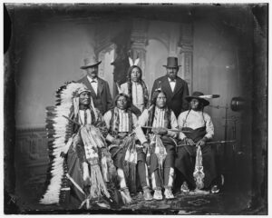
As the land along the Poudre began to fill up with squatters, Chief Friday’s band and a few others remained in their homeland, established friendly relationships with the new neighbors while also advocating for a reservation for the Northern Arapaho along the Cache la Poudre—land they had been guaranteed in 1851 and not signed away. Indian Agent Simeon Whiteley, however, considered the Northern Arapaho’s proposition unacceptable as the land they requested for their reservation bordered the Overland Trail and contained sixteen squatter families who were already building homes and farms (he conveniently ignored the fact that these families were technically illegally occupying the land). The territorial government of Colorado rejected Friday’s request.

By 1864, with many settlers filling the Front Range, Governor Evans needed to create a situation that would lead to the end of Native American claims to lands within Colorado. His following decisions lead directly to the Sand Creek Massacre in November of 1864 in which a peaceful camp of Cheyenne and Arapaho were attacked and over 200 women, children, and elderly were killed. In response to this massacre, conflict between Native Americans and Euro-Americans increased throughout Colorado and Wyoming (the division point of the Overland Trail, Julesburg, was destroyed). “Friendly” Cheyenne and Arapaho bands were ordered to military camps to protect them from government reprisals against “hostile” groups. Still advocating for a reservation, Friday and his band complied, moving to the camp in Laporte. The Northern Arapaho maintained peaceful relationships with the settlers in the Poudre region, even as their land was lost. By 1869, Friday’s band had joined the other Northern Arapaho in Wyoming, giving up hope for a reservation on the Poudre. Left without a reservation of their own, the Northern Arapaho were permitted by the Shoshone to dwell at their reservation, Wind River, in Wyoming. In 1878, Wind River became the Northern Arapaho’s permanent reservation alongside the Shoshone. In less than forty years, less than a generation, tribes across the west had lost their homelands.

From Camp to Fort Collins

In the same years the Arapaho and Cheyenne were losing their homes, new communities were springing up on the land. In 1864, a massive spring flood on the Poudre washed away the “tents, ammunition, blankets, and clothing,” of the military camp outside of Laporte. Instructed to find a better less-flood prone location, the 11th Ohio Volunteer Cavalry relocated to a spot along the Poudre that had, “superior advantages in the way of wood, water, and grass without the danger of overflow.” They named the new site Camp Collins in honor of Colonel W.O. Collins, then commander of Fort Laramie. (Located between the Poudre and Jefferson St where El Burrito and Ranchway Feed stand now). Along with soldiers, Fort Collins, as it later became known, attracted a few settlers frightened by the violence following the Sand Creek Massacre as well as Chief Friday’s Arapaho band. A small community of log structures including company and officer quarters, a temporary hospital, corrals, stables, a kitchen, guardhouse, laundry, and sutler’s store. Settlers erected their own homes and buildings nearby, including Elizabeth “Auntie” Stone whose cabin, now near the Main Library, is the only known remaining structure from the fort. Like Fort Laramie (and most western forts), Fort Collins never had wooden walls—just a handful of buildings and a flagpole next to a western river where the vast plains met the mountains.

Parade grounds and buidlings in Camp Collins, c1865. Archive at the Fort Collins Museum of Discovery, [H11255].

Christmas Dinner 1866 at “Auntie Stones Cabin” in Camp Collins. Elizabeth stone opened the mess hall with her husband in 1864. Left to right: Mr. Boulware, Mr. Fisk, Mrs. Gaylord, Dr. Van Stine?, Nell Smith, Larry, Auntie Stone, Mrs. Forbes, Captain Lakehart (camp store), Lizzie Chamberlain, Mrs. Dr. Smith and baby Katie, Mrs. Chamberlin, Mr. Frankfort, Mrs. Keays, Will Keays, Johnnie O’Brien. Archive at the Fort Collins Museum of Discovery, [H01419].

Soldiers in front of the professional enlisted barracks at Camp Collins, c1865. Archive at the Fort Collins Museum of Discovery, [H113256].

As 1870 rose, the world of the Poudre was different than thirty years earlier. Thirty more years would bring even more changes.

Explore!

Plan a visit to Fort Laramie National Historic Site

Although two and a half hours north of the Cache NHA, Fort Laramie is a wonderful addition if you’re planning a trip to the region or, if you live here, a great trip outside the Heritage Area to explore more of our history. Be sure to check their website for living history days!

Visit Antoine Janis’ & Auntie Stone’s Cabin

Two of the oldest structures in the Cache NHA have been moved to sit beside each other in the Heritage Courtyard in Library Park, Fort Collins. If you’re already planning a stroll through Old Town, take a detour a few blocks east for a peek at these buildings.

Note: The Heritage Courtyard and buildings are not currently open for visitors although you can get a good look through the fence. The Cache NHA does not have access to these buildings and cannot schedule tours. For more information, please contact the Archive at the Fort Collins Museum of Discovery.

Explore Laporte

The first town in Northern Colorado, the first county seat of Larimer County, a stage stop, a link on the Overland Trail, and more! Laporte is filled with hidden historic gems (like the Overland Trail marker and Bingham Hill Cemetery) and some fantastic views and restaurants. Hop in your car and take a drive (be sure to keep heading along the Poudre to explore Bellvue and the Poudre Canyon while you’re at it) or, better yet, grab your bike and walking shoes and head west on the Poudre Trail—the paved trail that runs along the river—you’ll end up in Laporte!

For ideas of what to explore in Laporte visit our Interactive Map.

Travel Through Virginia Dale

If you head north on 287 towards Laramie, WY (not the Fort, the other one) you’ll travel through Virginia Dale, one of the most infamous stops on the Overland Trail. While it may appear a ghost town, a small community still thrives here. The Virginia Dale Community Club owns the Virginia Dale Overland Stage Station—the only remaining stage station on the trail—and will give tours by appointment April-October. There are several small historic points of interest in the area.

References

Burris, Lucy. People of the Poudre: An Ethnohistory of the Cache La Poudre River National Heritage Area, AD 1500-1880. 2006.

“The Colorado Gold Rush, Early Settlement, and the Creation of Fort Collins, 1844-1866.” Historic Context from Fort Collins History Connection.

Colorado TerritoryColorado Encyclopedia from History Colorado.

Fort Laramie Treaty of 1851 (Horse Creek Treaty).” Fort Laramie National Historic Site from the National Park Service.

History.” From the Northern Arapaho Tribe (northernarapaho.com).

Joseph Antoine Janis.” from National Park Service: St. Genevieve National Historical Park.

Laflin, Rose. Irrigation, Settlement, and Change on the Cache la Poudre River. Colorado Water Resources Research Institute, 2005.

Marmor, Jason. An Historical and Archaeological Survey of the Overland/Cherokee Trails Through the Fort Collins Urban Growth Area. City of Fort Collins Planning Department, 1995.

Overland TrailColorado Encyclopedia from History Colorado.

The Overland Trail in WyomingEncyclopedia from WyoHistory.org

Treaty of Fort Laramie.” Colorado Encyclopedia from History Colorado.

Watrous, Ansel. History of Larimer County Colorado. 1911. Accessed on archive.org.